Our Earth is rotating, gyrating, revolving and is being drifted along with the sun; yet we feel not a stir
MAKING SENSE OF DIRECTIONS
Let us first understand some basic terms & concepts which will help us in understanding the motions of our Earth.
Ecliptic Plane and Ecliptic Poles (due to earth’s revolution around the Sun):
Ecliptic is the plane in which earth revolves around the Sun. Almost all planets revolve around Sun in the same plane. The imaginary axis passing perpendicularly through this plane is called the Ecliptic Axis and the respective poles on this Axis are called North Ecliptic Pole and South Ecliptic Pole respectively (right hand thumb rule). The North Ecliptic Pole points towards the constellation Draco, while the SEP points towards the constellation Dorado.
Celestial Planes and Celestial Poles (due to earth’s rotation on its own axis):
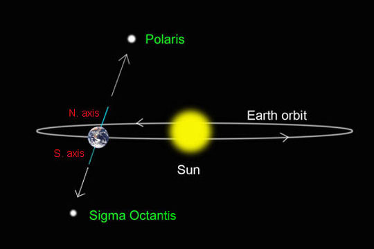
Celestial equatorial plane is the extension of Earth’s Equatorial plane. It is perpendicular to the imaginary axis around which the earth rotates. The poles on this imaginary axis are known as the Celestial North & South Poles (or simply as Earth’s North Pole & South Pole). The Celestial North Pole points towards the star Polaris (in the current epoch), also called as the North Star or the Pole Star. The Celestial South Pole points towards the star Sigma Octantis (which is rather dim). Note that the axis of the earth itself is in precession and changes its direction (about 1º per 71 years).
Celestial Sphere: It is an imaginary sphere of arbitrarily large radius, concentric with Earth. All objects in the observer’s sky can be thought of as projected upon the inside surface of the celestial sphere, as if it were the underside of a dome (like planetarium).
Zenith and Horizon: Zenith is a hypothetical point in the celestial sphere which is directly overhead above the observer or point in question. Zenith coincides with the position of Sun when the sun casts a zero shadow upon that person or point. (Nadir in celestial sphere is a point squarely opposite to Zenith). Zenith angle is the angle between Zenith and Sun measured from the observer on earth. For an observer on Equator, zenith angle is zero on an equinox noon.
Horizon is the lowest point in the sky which that observer can see. The lines to horizon and zenith from the observer make a right angle (the line to horizon can also be thought of as the tangent to the sphere from the point of contact of the observer).
Terrestrial and Celestial Coordinates:
We have Terrestrial coordinates (Latitude and Longitude) to identify a location on earth, and Celestial coordinates (Declination and Right Ascension) to identify a location in space.
Latitude of a given place is its angular separation from the equatorial plane, measured from the center of the earth. Alternatively, Latitude of a given place can be measured by the angle made by the tangent at that place with the polar Axis of the Earth. Else, the Latitude of a given place is 90º minus the angle made by the tangent at that place with the Equator (or the celestial plane). The easiest way to measure the Latitude of any place on earth is to measure the Zenith Angle at local noon at that place on the day of either Equinox. Thus, a point anywhere on the Equator has a latitude of 0º, while if it is on either of the Poles, then it will have a latitude of +90º. The points in the N.H are given a +ve sign of latitude while those in the S.H are given a -ve sign.
Longitudes or Meridians are diametrical circles passing through both the poles of earth. Of these lines, the one passing through the city of Greenwich is called the Prime Meridian. The Longitude of a given place is the angular separation between the plane of Prime meridian and the plane of the meridian passing through that place. (watch the video below).
Declination: It denotes the angular separation of a point in celestial sphere from the celestial plane, measured from the centre of earth. Thus, it is nothing but the extension of earth’s latitude into the celestial sphere. It is measured in degrees. In case of Sun, the declination is the angle between the light rays from the Sun and the Earth’s equator. One must have a friend in a city on equator (like Quito or Kampala) to call him up and ask the Sun’s declination on a given day. Otherwise, you can calculate it with a rough measure of change of 0.25º per day or 1º every 4 days (click here to read the mathematical formula).
Elevation, Inclination or Altitude is the angle of Sun or any celestial body from the plane of horizon of the observer. It is complimentary to Zenith angle, so that Elevation = 90º – Zenith angle. When we use Clinometer, we obtain the angle of Elevation/Inclination of the celestial object. Also note that the Elevation of sun at any given place will change with time. Hence, of all the elevations of sun at a given place on any given day, we are generally interested only in the one which is the maximum for that day (or the minimum angle of Zenith of the day), which occurs at local noon.
Right Ascension: It is the celestial equivalent of terrestrial Longitude. But where is the zero degree mark in the sky separating east from west? Recall that the terrestrial Prime Meridian was chosen arbitrarily as the meridian passing through a place called Greenwich. Similarly, Astronomers have chosen an arbitrary longitudinal plane in the sky. This plane is parallel to the Axis of Earth and passes through the point of position of Sun at Vernal Equinox. Presently, it’s located in the constellation of Pisces. Thus, Right Ascension denotes the separation of a point in celestial sphere from the said plane. Note that this separation is not angular but is given by difference of time (in hrs, min & sec).
Two other coordinates are also in use: altitude and azimuth, but they are local coordinates, not universal.
Experiments For Learners:
DIYHA (do it yourself home activity):
1. Practical 1: Find the height of a tree or building near you.
2. Practical 2: Suppose you know the distance between two cities. Then find the circumference of earth using the Sun as reference.
3. Practical 3: Find the latitude of your place using sun and stars.
4. Practical 4: Finding the longitude of your place using John Harrison’s method.
5. Practical 5: Using the sun as reference, find the distance of your city from any other city.
6. Practical 6 (Thought Exercise: Terrestrial vs Celestial Equator): Suppose you are atop a watch tower at a sea shore on equator. Mentally chart out the path of the two Equators.
7. Practical 7 (science of a rotating sphere): Ceiling-light or the ceiling-fan experiment to understand the concepts related to poles and rotating sphere.
8. Practical (shadows): Understanding the formation of shadows.
9. Take the School Exam Quiz on this topic.
For Educators & Researchers:
1. Explain how GPS works through Trilateration and how are unique coordinates assigned to a place. How have these coordinates changed over the years.
2. Explain whether Pole stars coincide with the celestial poles even as the earth revolves round the sun?
3. Write a paper on the effect of earth’s axial precession (nutation) on its seasons.
4. Devise an experiment to find the longitude of the given place without using a clock.
5. Devise an experiment to find the distance between two cities
6. Make a 365-day activity calendar for various activities such as charting out Analemma, measuring sidereal day, positions of moon, planets, stars, etc.
ऋषि उवाच
1. ok
2. कोणे नता पृथ्वी मुख्य कारणं । सूर्यात दूरी समुद्रः च गौण।
To discuss or suggest more experiments, LOG IN here.
SEASONS ON EARTH
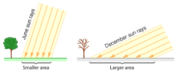
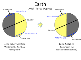
Have you ever wondered what brings about the change in Seasons on Earth? Well, Earth’s TILT is the main reason. Areas receiving sun rays at 90 degrees get most heat. As this angle decreases, hotness decreases. So, the Season (temperature) at any given place on earth is the manisfestation of the angle of incident sun rays at that place.
To understand in detail, log-in here.
For Learners:
DIYHA (do it yourself home activity):
1. Practical 1 (Insolation): Understand how the heat density changes with straight and angular light beams.
2. Practical 2 (Tilt of earth’s axis): Understanding the cause of Seasons on earth.
3. Understanding the 3 major Climate zones: learn from the net.
4. Take the School Exam Quiz on this topic, log-in here.
For Educators & Researchers:
1. Devise an experiment to measure Insolation.
2. Devise an experiment to measure the radiation of heat by earth.
ऋषि उवाच
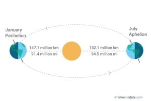
1. कोणे नता पृथ्वी मुख्य कारणं । सूर्यात दूरी समुद्रः च गौण।
2. k
To discuss or suggest more experiments, LOG IN here.
FOUR MAJOR MOTIONS OF EARTH
Do you know that the seat of your rest, i.e the earth, is constantly moving in various directions?
1. Rotation
The earth rotates at the same angular speed at all places on earth. However, it has different linear speed at different latitudes: speed of 1675 km/hr at equator and at a speed of 300 km/hr near the poles (80º latitude). The exact speed of rotation in km/hr at a given latitude is: 1675 x cosine(latitude).
Earth’s rotation, along with gravitational effects of sun and moon, causes the earth to bulge at the equator. The equatorial circumference of earth exceeds its polar circumference by about 67 KM.
2. Revolution
Earth revolves at an average speed of 30 km/s around the sun (or 1.07 lakh km/hr).
3. Precession
Precession of earth’s axis causes the equinox points to drift westward at a rate of 50.3 arcseconds annually. As the equinox shifts, it drags the coordinate grid with it. That’s why star catalogs and software programs have to be updated regularly to the latest “epoch.” This is done every 50 years. Most catalogs and software currently use Epoch J2000.0 coordinates (for the year 2000). The next major update will happen in 2050. To know more about Earth’s precession, log-in here.
4. Drag with Sun
For Learners:
DIYHA (do it yourself home activity):
1. Practical 1 (Thought Exercise): How would you determine the length of day in each of the following cases:
(i) Imagine that a straight earth is rotating in a blank space.
(ii) Imagine that a straight earth is rotating as well as revolving in a blank space.
(iii) Imagine the set-up of (ii) with Sun as the centre of earth’s revolution.
(iv) Imagine the set-up of (iii) with a tilted earth.
(v) Imagine the set-up of (iv) with a distant star (fixed).
2. Take the School Exam Quiz on this topic, log-in here.
For Educators & Researchers:
1. Write a paper on how the seasons of earth change in different epochs due to earth’s axial precession (nutation).
ऋषि उवाच
1. ok
2. कोणे नता पृथ्वी मुख्य कारणं । सूर्यात दूरी समुद्रः च गौण।
To discuss or suggest more experiments, LOG IN here.
ECLIPSES AND OTHER RELATIVE POSITIONS
Do you know
1. Solar Eclipse
It is the blocking of Sun by moon when viewed from earth .
2. Lunar Eclipse
It is the blocking of Moon by earth (when viewed from earth).
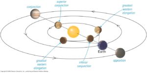
3. Conjunction, Elongation & Opposition
Earth
4. Retrograde and Prograde motion
Earth
For Learners:
DIYHA (do it yourself home activity):
1. Practical 1 (Earth-Moon distance): There are two methods.
2. Take the School Exam Quiz on this topic.
For Educators & Researchers:
1. Write down
ऋषि उवाच
1. ok
2. कोणे नता पृथ्वी मुख्य कारणं । सूर्यात दूरी समुद्रः च गौण।
To discuss or suggest more experiments, LOG IN here.

LOCATING STARS WITH R.A COORDINATES
LEADING ARTICLES
Do you know
1. Solar Eclipse
The .
2. Lunar Eclipse
ok
QUIZ
Each of the following questions has four answer options: a, b, c, d. Choose the correct one.
1. If you are situated anywhere at the Tropic of Cancer then your shadow can never point in this direction:
(a) North
(b) East
(c) South
(d) West
2. Consider the factors causing change of seasons on earth:
(i) Distance from the sun.
(ii) Rotation of earth around sun.
(iii) Precision of earth’s axis.
(iv) Tilt of earth’s axis.
Which of the following are the main factors responsible for change of seasons on earth?
(a) (i) and (ii)
(b) (i) and (iv)
(c) (ii) and (iii)
(d) (ii) and (iv)
3. The maximum possible range of Sun’s declination is:
(a) 23.45º
(b) 45º
(c) 46.9º
(d) 90º
5. The angle of the shadow formed by Sun at the flat earth’s surface is equal to the angle of:
(a) Latitude
(b) Longitude
(c) Inclination
(d) Declination
6. Match the following:
(a) 23:56:04
(b) 23:45
(c) 365:05:48:56
(d) 40,075 and 40,008
(e) 1.07 lakh and 1675
(f) 15.2 cr and 14.7 cr
(g) 4.05 lk and 3.60 lk (km)
(h) 8.28 lk and 25 cr
(i) 110.6 to 111.7
(j) 111.3 to zero
(k) 15′
(l) 0.257 and 3.89
(m) 1.97
—
(A) apogee and perigee distance between earth & moon (in km). The difference is 45k km.
(B) speed (km/hr) at which solar system is hurtling through MW galaxy and the duration (in earth years) of 1 revolution (galactic year).
(C) apogee and perigee distance between earth & sun (in km). The difference is 50 lakh km.
(D) average speed (in km/hr) of earth’s revolution and earth’s rotation (at equator)
(E) equatorial & polar circumference in km
(F) length of year in d:h:m:s
(G) angle of tilt of the earth’s axis to the plane of ecliptic
(H) length of sidereal day in h:m:s
(I) Distance per degree of Latitude (in km) at equator and at poles.
(J) Distance per degree of Longitude (in km) at equator and at poles. Away from the equator, this distance is 111.3 x cos(lat.)
(K) 15 minutes of arc variation occurs per day and per minute in Latitude and Longitude respectively.
(L) Angular change (in degrees) of Sun’s declination (i.e in the angle between equator and sun rays), and Number of days required for 1º change in Sun’s declination.
(M) This is the factor you have to multiply with your height (in feet) to find the distance to horizon (in km)
BMT (Bharat Mean Time) is a convenient reference for Time Difference from India
(Lahore of undivided Bharat taken as reference because of whole number with respect to GMT/ UTC).
| CITY/ COUNTRY | BMT + | GMT/UTC + |
| Alaska | -13 | -8 |
| California, Seattle, Vancouver | -12 | -7 |
| Salt Lake City | -11 | -6 |
| Peru, Colombia | -10 | -5 |
| Chicago, Texas, Mexico City | -10 | -5 |
| Florida, WDC, New York, Montreal | -9 | -4 |
| Chile | -9 | -4 |
| Rio de Janerio | -8 | -3 |
| GMT (London) | -5 | 0 |
| Italy, Germany, Norway | -3 | 2 |
| Egypt, S. Africa | -3 | 2 |
| Turkey, Moscow | -2 | 3 |
| Dubai | -1 | 4 |
| Kazakhastan | 0 | 5 |
| LAHORE | 0 | 5 |
| INDIA | 0.5 | 5.5 |
| Thailand | 2 | 7 |
| Indonesia | 3 | 8 |
| Singapore, Malaysia | 3 | 8 |
| China | 3 | 8 |
| Perth | 3 | 8 |
| Tokyo | 4 | 9 |
| Sydney | 5 | 10 |
| NZ | 7 | 12 |
